OLGA TRAVERSO, Arqueología oculta y la Atlántida
Olga María Pérez-Traverso Romero es escritora, formadora, terapeuta y conferenciante; Naturópata y experta en Biología Celular-Molecular y Biotecnología. En los 26 años de trayectoria y formación dentro de las ciencias, la filosofía, las artes naturales y del saber esotérico y ancestral, ha tenido la oportunidad de formarse en areas tan diversas como: la Astrología, la Quirometría, la Cromoterapia, la Gemoterapia, la Numerología, la Alquimia, el Chamanismo Tibetano y Mesoamericano; Cábala, Antroposofía, Metafísica, P.N.L., Geometría Sagrada, Reiki, Prana, Tensegridad, Psicología, Psicometría, Filosofía, Teurgia o Alta Magia, Mancias Oraculares como: Tarot, Runas, Radiestesia, Quirología o Geomancia, Física Cuántica, Bioenergía, Naturopatía, Dietoterapia, Fitoterapia, Ciencia Eneagrámica, Flores de Bach, Terapia Aura-Soma, Taoísmo, Budismo, Tantra, Raja Yoga, Agni Yoga, Método Silva, Angeología, Ciencias Mántricas y Múdricas, Sistemas Iniciáticos de Horus, de Isis, y Occidental etc, etc.
Actualmente realiza una labor de síntesis de las principales corrientes filosóficas, científicas y religiosas de todos los tiempos, en un afán de recuperar, reconstruir y difundir el Saber que un día fue impartido en las Antiguas Escuelas de Sabiduría.
Título de la conferencia: "Arqueología oculta y la Atlántida"
Más allá de la afirmación y de la descripción que el filósofo griego Platón nos legase a través de sus obras, de una antigua civilización que regía en tiempos ante-diluvianos sobre la faz de la Tierra, numerosos registros arqueológicos no sólo apoyan la veracidad de esta realidad, sino que nos ofrecen información adicional que nos lleva a valorar la posibilidad de que dicha civilización pudiese haber estado más avanzada que la raza humana actual a nivel tecnológico y espiritual, así como que este avance podría guardar algún tipo de conexión con alguna clase de vínculo o contacto con civilizaciones extra-planetarias.
http://luispalacios-reporterosciudadanos.blogspot.com/
http://lacajadepandora.org/
Existe una hermandad llamada la Lemurian Fellowship que cuenta el sistema de Lemuria en el libro The ultimate frontier, que describen un Gobierno Avanzadísimo que existían en Lemuria que duró unos 52.000 años y que fue destruido por guerras y cataclismos hace unos 26.000 años.
Todo el Pacífico e Índico están llenos de ruinas colosales de Lemuria , como Pohnpei, Ayers Rock, Nan Modol, Isla de Pascua, Allice Springs, Pilares de latte...
La Lemurian Fellowship hablaba de un sistema que era casi perfecto en ciencia, religión, política, tecnología y conviviencia.Las pirámides y monumentos las hacían por levitación con mantras. No hay explicación a esas construcciones en la Prehistoria.
Puede parecer un pajote mental, pero lo cierto es que esta secta describió la placa tectónica del Pacífico antes de ser descubierta.
En la Sociedad de Mukulia había una sola lengua y un solo gobierno. La educación era clave y te educaban para ser un Santo o Maestro, esa era la meta de la Sociedad: la autorrrealización. Un niño tenía que estudiar hasta los 21 años para asistir a la escuela de ciudadanía. Hasta los 28 años no eras ciudadano del imperio. Para tener un cargo público vitalicio tenías que prepararte 7 años. la discapacitada neuronal Leire Pajín Mental no habría tenido cabida en este sistema… o la habría puesto de palanganera en un puticlub… Bueno no hay que decir que un sistema así no hacen falta puticlubs… en un sistema sin dinero…. la prostitución y sobre todo la Mafia, desaparecerían…que son la base del timo capitalisto.
SUPER IMPERIO DE LEMURIA, UNA REALIDAD IRREFUTABLE
Que hubo un gran continente, Mu, Mukulia o Lemuria, con una civilización mas avanzada que la actual es irrefutable, toda vez que hay inexplicables ooparts y ruinas gigantescas en todo el Pacífico e Índico.
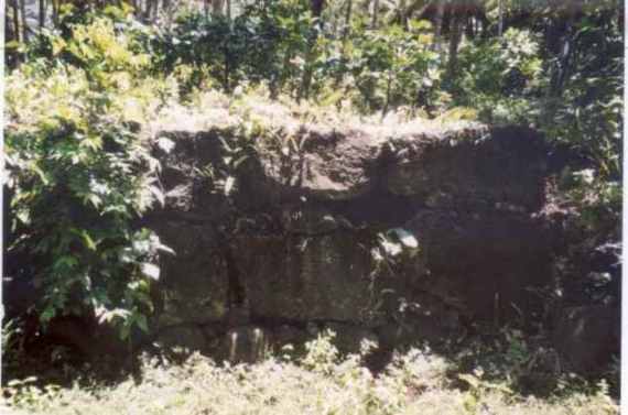
Hablamos de las Ruinas enormes de Ponhpei,
los pilares latte de las Islas Marianas,
las piedras moumentales de Nan Modol,
las pinturas de aliens de Kimberleys,
 Kimberley al noroeste de Australia, es una zona remota, tan poco poblada como visitada, con grandes ríos y magníficos paisajes de tonos rojizos. Es esta zona fueron descubiertas en el año 1838, gran cantidad de pinturas rupestres un tanto especiales, Los aborígenes los llaman “wandjinas”.
los templos gigantes de Kiribati y las Marshalls,
las pirámides tapadas de montañas de la isla de Rapa Iti,
los moais de la Isla de Pascua que tienen cuerpos enterrados y son Espíritus, las piedras prehistóricas de la isla de Babeldaub (fijaos el nombre sumerio…Babel..),
Stone statues or monuments in Belau are one of ten elements that define Level 1, a “village settlement system” of a two level settlement system research model. Archaeologists conducting island-wide surveys have classified artifacts, areas, or features into three categories: discrete portable objects (potsherds, chipped and ground stone); discrete non-portable features (platforms, statues, uprights); and non-discrete, non-portable areas (terraces).
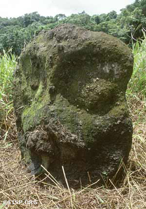
Monolith number 28 at Ngereklngong (total height 1.03 m) is an example of type variety A1 (called Chesuch or “owl”). Photo by David C. Ochsner, ©1987 Jo Anne Van Tilburg.
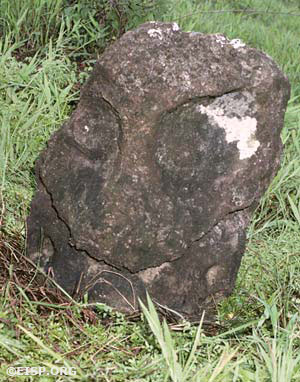
Monolith number 22 at Bairulchau (total height 1.74 m) is an example of variety A3 (“fanged mouth”). Photo by David C. Ochsner, ©1987 Jo Anne Van Tilburg.

Monolith number 01 (total height, 85.4 cm) at Ngerbodel is the only figure (type D) documented in Belau that unambiguously consists of head and torso carved out of one piece of stone. Photo by David C. Ochsner, ©1987 Jo Anne Van Tilburg.
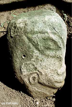
Monolith number 10 (total height 42.3 cm) was excavated on property belonging to the Omenckngkar family at Melekeok and is called by the name of a god, Mengachui. It is an example of figure type variety B5. Photo by David C. Ochsner, ©1987 Jo Anne Van Tilburg.
We located thirty-eight monoliths on the islands of Babledaob and Oreor (Koror), twenty-eight of which had human features.
el camino de Rarotonga,
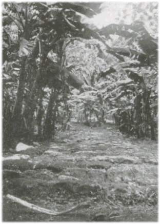
Fig. 10.11 Paved road encircling Rarotonga.5
los senderos o carreteras de la Isla de Malden,
huellas de gigantes en las Kiribati,
las tumbas de los reyes de Tuitonga,
el arco de piedra de Tongatapu (que se parece algo a la Puerta del Sol de Tiahuanaco),
las plataformas fotografiadas por Len Beadell,
Ayer´s Rock, la extraordinario formación de las Olgas que parece un observatorio,
las rocas talladas de Allice Springs en Australia, Mohenjodaro y Harapa en Pakistán, pinturas aborígenes de Groote Eylandt,
la piedra tjuringa del culto al Sol que parece un shamash sumerio,
estatuas de aspecto feniciel río Hawkesbury,
las piedras de los templos de Las Maldivaas que visitó el explorador Heyerdal demostrando que los egipcios pudieron navegar hasta el Pacífico-Índico, las estatutuas con orejeras de la Atlántida de las Maldivas….
Así podría citar miles de pruebas…
En un dibujo del libro The vogage of McDuff de 1799 hasta aparece en Tahiti una pirámide como las mayas escalonadas y la de Sakara.
Es un hecho que toda la arquelogía oficial es una farsa del Instituto Smithonian.
Hubo grandes civilizaciones imperios mundiales anunnaki,reptilianos y anteriores que nos precedieron con una tecnolgía muy superior y hubo grandes guerras y cataclismos que acabaron con estas culturas…pero no del todo… siguen por aquí, pero muy OCULTOS…
LOS 10 PRINCIPIOS DE LA HOLOCRACIA EN LEMURIA
El fin del sistema erea ser Maestro. Estabas todas las vidas preparándote, porque esa gente conocía la realidad de la reencarnación.
Mukulia se regía por 10 principios. Conviene recordarlos y alucinar un poquito:
1- Ningún hombre se beneficiará a expensas de otro.
2.- Ningún hombre individualmente ni la República colectivamente puede quitarle nada a otro por la fuerza.
3.- Todos los recursos naturales segurán siendo propiedad del estado o la República o pueden ser reclamados como posesión personal por ningún individuo. Estos sistemas comunistas funcionaban hasta con los incas y aymaras.
4.- Todo ciudadano recibe la misma elevada educación.
5.- Toda mejora de la posición se basa en el mérito.
6.- Ningún individuo tendrá derecho a retern como poseión personal nada que no haya compensado personalmente por igual valor.
7.- Ningún individuo tendrá derecho a intervenir en el entorno o asuntos personales de otro a menos que éste se lo pida. El Gobierno interviene solo si hay abuso.
8.- Nadie puede matar, excepto en defensa propia o del Estado.
9.-El hogar es inviolable.
10.-El Consejo de Ancianos decidirá todo.
SOCIOHOLISMO: DICTADURA DE SADVIPRAS
Como se ve este sistema es una Dictadura, pero de Sabios.
La democracia ya dijo Platón que era una basura, el absolutismo del número.
Los mejores o “aristois” son los que tienen que mandar. Eso es lo significa aristocracia, aunque el término estas prostituido por los mass media:
El hombre autorrealizado de Maslow es el que debería gobernarnos:
ha pulido su ego y conocido ananda y ahora las distribuye a otros.
En Mukulia lo principal es la evolución, el despertar , el autorrealizarse. Esto es igual en los andromedanos y pleyadianos. Collier lo llama “Sociedades Holográficas”, yo “Sociedades Holocráticas” o Socioholismo.
El sistema tiene que elevarte , no dregadarte como el actual .
Anandamurti y su PROUT :
Su modelo se parece bastante al de Mukulia, se prospera por el mérito y gobiernan yoguis Sadvipras que son “monjes que se gobiernan a sí mismos”.
Lemuria! Mainstream history has chosen to forget about this lost continent that once existed in the Pacific. But to many esoteric researchers, including me, Lemuria should be included in academic text-books. One such educational book that does include Lemurian history was published by an obscure Rosicrucian sect called The Stelle Group or The Lemurian Fellowship based out of Stelle, Illinois and San Jose, California respectively.
 I managed to get my hands on a copy of this rare text-book entitled ‘The Ultimate Frontier’ ©1963, (Exhibit A), and the inside jacket cover says the following:
“Some of the…fascinating subjects discussed in THE ULTIMATE FRONTIER are:
- Evidence of a magnificent civilization that once flourished on the now submerged continent of Lemuria in the Pacific Ocean.
- A moving story of communities that are actually living by this [Lemurian] philosophy.
- A Master Plan, dating from 4700 B.C. and involving the Great Pyramid, for establishing in October A.D., 2001 a new nation dedicated to the uplift of all mankind.
THE ULTIMATE FRONTIER describes the mysteries of human existence…and may well mark the beginning of a much greater phase of Western Civilization.”
I must admit, the intro of this book does seem a little ‘cultish’ but I believe the Rosicrucians are onto something here to suggest the Lemurian Continent was very physical and very real. Why did Lemuria submerge into the Pacific Ocean? According to North American Rosicrucian adepts this occurred because of a pole shift.
More importantly though, what was the reason or ‘trigger’ for a pole-shift? I’ve always argued that a pole-shift can only occur from the magnetic field interaction of a planetary body passing near-by such as Nibiru. Have the Rosicrucians and Freemasons acquired ancient knowledge of this celestial intruder? I say yes, and each brotherhood gives tantalizing clues of this through symbolic pictures.
They also speak of a ‘Dark Satellite’ and a ‘Blazing Star.’ (See Andy Lloyd’s ‘Aphelion in 1881 & Freemasonry’ web-page) Before getting into that, however, let’s first look at this mysterious continent known as ‘Mu’. I’ve included [brackets] and CAPITALS to emphasize my argument.
THE LOST CONTINENT OF ‘MU’
Exhibit B) David Hatcher Childress (Lost Cities of Ancient Lemuria & the Pacific ©1988)
 “One of the great proponents of Lemuria [or MU] was James Churchward, an Anglo-American who spent a great deal of his life in India. Here he was initiated into certain eastern esoteric “truths,” being shown, supposedly, some ancient tablets in an Indian/Tibetan monastery. [See ‘Nibiru and the Subterranean Connection – Part One”—GJ] (There have been many Tibetan monasteries in India for hundreds, if not thousands of years.) He was taught how to read the tablets and was told many fascinating things about ancient history. Then, after traveling all over the world, he wrote a series of very popular books. [The first one entitled] "The lost Continent of Mu…”
 “Churchward’s books added a great deal to the store of information available on Lemuria. While Churchward had his inaccuracies, he nevertheless had many interesting things to say. Furthermore, one can find substantiation for much of his information.”
“In the year 1900 at Dunhuang, a small desert town on the border of northern Tibet, a Taoist monk found a hidden library inside a cliff honeycombed with caves. The room had been walled up with bricks in the eleventh century to keep it from falling into the hands of invading barbarians. For eight hundred years the books had lain there, preserved by the dry desert air and maintained in excellent condition. Then the famous explorer and archaeologist Sir Aurel Stein passed through Dunhuang in 1907 and persuaded the monk to allow him to view the treasure, which was at the time still kept in the secret [subterranean] cave.”
“He found Buddhist texts in many languages—Chinese, Tibetan, Sanskrit—and some in languages that were completely unknown! Just how old some of the texts were was impossible to tell, but they had probably already been copied over several times from earlier texts. The originals could have been written hundreds and perhaps thousands of years ago. Amazingly, one of these manuscripts had FRAGMENTS OF AN ANCIENT MAP WHICH SHOWED PARTS OF A CONTINENT IN THE PACIFIC OCEAN!” Pages 7-8.

The above map was obtained from Lemuria—Lost Continent in the Pacific ©1931 (Exhibit C) published by the AMORC Rosicrucians of San Jose, California. It shows a submerged Lemuria after the cataclysmic pole-shift. Note also the Brazilian Amazon Sea.
Exhibit B) David Hatcher Childress (Lost Cities of Ancient Lemuria & the Pacific) continues:
“Something else which lends credibility to the belief that these secret libraries exist is the fact that many references are made to them in Central Asian literature. It is said that they can be found in many temples in India, Nepal and Tibet. They probably can be found in China and Mongolia as well.
 "About forty years ago, a Chinese representative of the ROSICRUCIAN BROTHERHOOD visited the Rosicrucian Fraternity in San Jose, California. He brought with him a manuscript which had been kept in a secret Asian archive for thousands of years. It was said to have been authored by the Egyptian Pharoah Akhnaton, historically the founder of monotheism. The Rosicrucians translated this book and published it under the title Unto Thee I Grant. [©1931] The appearance of this book would seem to illustrate that such archives do in fact exist, and that knowledge is occasionally disseminated from them. Furthermore, the Rosicrucians claim to have access to a number of secret [subterranean] libraries in Tibet. [See ‘Theosophy and the Dark Star’—GJ] Therefore, one can see that the idea of Churchward having access to some “secret” tablets, fantastic though it may seem, is really not so far fetched.” Page 8.
“The founding fathers of the United States included many Masons as well as several Rosicrucians. The history of both of these groups can be traced back to the ancient Mystery Schools of Egypt; the same Mystery Schools that had taught Moses! Had the secret teachings of the Masons and Rosicrucians been based on information which had been passed down for thousands of years through Egypt, originally having come from some lost civilization? It occurred to me that this was possible, and certainly, both MASONS AND ROSICRUCIANS HAVE ASSURED ME IT IS INDEED THE CASE.” Page 29.

“…according to The Lemurian Fellowship…the Elders of Lemuria, known as the “Thirteenth School,” moved their headquarters prior to the [pole-shift] cataclysm to the uninhabited plateau of Central Asia that we now call Tibet. Here they supposedly established a library and school, and became known as “The Great White Brotherhood.”
“…the great Chinese Philosopher Lao Tzu talked frequently of “Ancient Masters” and their profound wisdom. Loa Tzu was born more than two and a half thousand years ago in 604 B.C. He wrote the famous book, the Tao Te Ching, probably still the most popular book ever written in Chinese. When he finally left China, near the close of his very long life, he journeyed to the west, to the legendary land of Hsi Wang Mu. According to the ancient Chinese, this was the headquarters of the “Ancient Ones.”
“…Lao Tzu wasn’t the only Chinese to go off in search of the Abode of the Immortals. The Chou dynasty emperor “Mu” (strange coincidence, eh?) journeyed to the land of the Kun Lun mountains…the “Mount Olympus” of the Central Asia and ancient China, in order to contact the “mysterious, profound and wise Ancient Masters.” Were these legendary Masters identical with the masters of … “The Great White Brotherhood” spoken of by The Lemurian Fellowship? It is an intriguing possibility. Pages 48-49.
Could the GREAT WHITE BROTHERHOOD be the same group as the LOST WHITE BROTHERS from Hopi Indian tradition? I believe so! See ‘Nibiru and the Subterranean Connection – Part Two’—GJ.
“… The Ultimate Frontier [states that] Lemuria had been a large continent in the pacific which had encompassed all the present-day Australia, New Zealand, the Philippines, Oceania, western North America, and everything in between. The continents’s real name had been Mukulia or Mu…’ Page 27.
“According to the Fellowship, these Lemurians built great cities out of … stone and, under the direction of the so-called Elders, went on to create an “advanced” civilization. As the Mukulian Empire grew, more people wanted to be part of it. Persons from all the valleys of Mukulia eventually joined the “Empire of the Sun.” Page 352.
“The Ultimate Frontier…says the Lemurian, or Mukulian civilization “…lasted in the form of an empire for 52,000 years and reached heights so great that our present civilization can barely be considered a civilization when compared to it. Government, religion, and science achieved such perfection as to be far beyond our present comprehension. Western Civilization is only about 2,500 years old and has narrowly survived its power-seeking rulers and priests. Our science and technology are but in their infancy and as yet consist of relatively few rediscoveries.” Page 28.
“…Mankind’s first civilization rose 78,000 years ago on this giant continent and it lasted an astonishing 52,000 years. It was destroyed in earthquakes which had been generated by a “pole shift” occurring some 26,000 years ago, or at approximately 24,000 B.C. The continent was so large, that when it sank, the oceans of the world became drastically lowered as water rushed into the newly formed Pacific Basin. The relatively small islands which had existed in the Atlantic during the time of the Lemurian civilization were left high and dry by the receding ocean. The newly emerged land joined the Poseid Archipelago of the Atlantic Ocean to form a small continent. This continent is called Atlantis by historians today. Its real name was Poseid.” Page 28. [See ‘Nibiru and the Atlantean Connection – Part One’—GJ]
“The Mukulian Civilization had survived many pole shifts previously, building its structures out of gigantic blocks of stone fitted together in structures designed to last tens of thousands of years. Because the area of the Hawaiian Islands were one of the pivot points in the pole shifts that took place every ten thousand years or so, the citizenry of the Mukulian Empire were generally spared the massive destruction that typically takes place in such an event.” [So says the American Rosicrucians—GJ]

“However, when open war broke out between [two factions] according to The Lemurian Fellowship, the Empire was [finally] on the verge of collapse, and during a[nother] pole shift, the tectonic plate shifted downward, raising the South American continent and creating new land areas as the waters of the world poured into the Pacific Basin. Colonel James Churchward described it as the continental arch buckling during a pole shift.” Page 352.
THE GIANTS OF MU
Exhibit B) continues:
“Theosophist named W. Scott-Elliot, wrote a lengthy paper called The Story of Atlantis and the Lost Lemuria [©1896] and according to…Elliot, Lemurians were between twelve and fifteen feet tall. Their faces were flat, save for a protruding muzzle, and they had no foreheads… and their eyes were set so wide apart they could see sideways as well as forward…” Page 9.
“In Pathways to the Gods, [©1982. Erich] Von Daniken relates a number of legends [from a tiny island in the middle of the Pacific called Nauru] that involved gods [little g] coming from the sky…One of the gods has the name Nareau, which is perhaps where the name Nauru came from. Von Daniken eventually finds the stone grave of one of the giants…The grave is 5.3 meters long and piled high with stones.”
“He relates the local legend that goes along with the graves: that two Giants, apparently brothers, came to the island. They were twice as large as normal men and could lift massive stones and do other feats of great strength. The islanders, afraid of these giants, got them drunk on palm wine and then killed them so they could not do any mischief. They were buried in pits and covered with stones.”
“…What was most interesting to Von Daniken, and to me, were the GIANT FOOTPRINTS of Tarawa. A book has even been written about them, entitled The Footprints of Tarawa (it is extracted from the Journal of the Polynesian Society, Vol 58, No.4, December 1949, Wellington, New Zealand, and written by I.G. Turbott). This book mentions a number of places where these footprints can be found in the Kiribatis, [Islands] but the main spot is in the village of Banreaba at a spot called Te Aba-n-Anti, the “Place of the Spirits,” or Te Kananrabo, “the Holy Place.”
“Here various footprints can clearly be seen in the volcanic stone, some of them so huge as to seem impossible. MOST HAVE SIX TOES ON EACH FOOT. The largest are about three feet long, easily twice as large as the foot of an especially tall person…The footprints are reported to be very clear, with the toes, heels and outline distinct: naturally rounded and curved like a normal footprint. They were certainly not natural rock formations coincidently formed into footprints…These men [Giants] apparently had six toes and were probably ten to twelve feet tall…” Pages 192-193
“According to The [Rosicrucian] Lemurian Fellowship and other sources, many inhabitants of the Pacific continent were in fact GIANTS, some standing twelve feet tall or more…Possibly, in the final submergence of the continent in a pole shift, survivors of the many waves of earthquakes and tidal waves sought refuge in the very peaks of mountains, many of which were volcanic. Shortly before or after the final submergence, these survivors (who probably didn’t survive) walked on the lava that was to become the Kiribati islands. This may have happened as recently as 24,000 years ago, if we are to believe The Lemurian Fellowship’s date for the submergence of this continent…”
“…As to giants with six toes who are twelve feet tall, Frank Edwards reports in his book, Stranger Than Science, [©1959] that in 1833, soldiers digging a pit for a powder magazine at Lompock Rancho, California…hacked their way through a layer of cemented gravel and found the skeleton of a man about twelve feet tall. The skeleton was surrounded by carved shells, huge stone axes, and blocks of porphyry covered with unintelligible symbols. The giant also had a double row of teeth, both upper and lower! When local Indians began to attach religious significance to the skeleton and artifacts, the authorities ordered it secretly buried, to be lost to science.”
“Edwards goes on to say in his book: “This particular giant, incidentally, bore marked similarity to another, that of a giant man with double rows of teeth whose skeletal remains were dug up on Santa Rosa Island, off the California coast. Subsequent research has shown that he, or his descendants, feasted on the small elephants which once lived on that island and which have vanished, like the giants who ate them, countless ages ago.”

“Near Crittenden, Arizona, in 1891, workmen excavating for a commercial building came upon a huge stone sarcophagus eight feet below the surface. The contractor called in expert help, and the sarcophagus was opened to reveal a granite mummy case which had once held the body of a human being more than twelve feet tall—a human with six toes, according to the carving on the case. But the body has been buried so many thousands of years that it had long since turned to dust.” Page 194.
At this point I raise the question, whatever happened to the granite case depicting a detailed carving of the giant? As I’ve stressed before in my last essay, these artifacts conveniently go missing for the purposes of controlling our current paradigm of mainstream history.
“So, we suddenly see a correlation with six-toed giants on the west coast of North America with six-toed giants leaving footprints in ancient strata in the [Pacific] Kiribati Islands.” Pages 194-195
In Exhibit 13 from my paper: ‘Nibiru and the Atlantean Connection – Part Two,’ the reader will notice that the Irish Giant also has six toes and is approximately twelve feet tall. Just like the Polynesian Giants! The similarities are uncanny. Coincidence? It seems unlikely. Throughout my essays, I’ve been insisting that Giants had roamed the entire globe—within and on top of Earth—from some long forgotten age. And one such distant outpost that documented and recorded the Giants of Lemuria comes from Easter Island.
According to James Churchward, Easter Island was originally part of Lemuria akin to the Azores being originally part of Atlantis so it’s reasonable to consider tangible evidence would have been left behind documenting the Giant Lemurian race.
As it turns out, researcher and explorer Harold Wilkins addressed this by suggesting the original inhabitants were indeed Giants and that local islanders recorded what the Lemurians looked like, they replicated their “Taskmasters” in the form of giant statues. See below:
Exhibit D) Harold Wilkins (Mysteries of Ancient South America ©1946)
“…who were these strange people who left the amazing number of 550 colossal images in Easter Island, of whom not even the unquiet sea whispers tales of old, unhappy things and battles long ago? May be, the answer is…in the book of Genesis: “There were giants on the earth in those days…” Page 28.

In James Churchward’s book, The Lost Continent of Mu ©1926, (Exhibit E) he includes a map (see below) showing Easter Island and Hawaii being part of a larger Pacific landmass:

Another clue that lends credence to Easter Island and Hawaii being part of a larger continent comes from the same Giant Stone Heads found on each island. Notice the amazing facial similarity between the two images shown below, especially the lips. Are they ‘stylized’ replicas of Giants that once roamed Lemuria? I say yes!
| Giant Head Statue | Giant Head Statue |
 |  |
| From Easter Island | From Hawaii |
Harold Wilkins had some interesting things to say about these colossal heads and the Giants of Easter Island. He writes the following:
Exhibit D) Harold Wilkins (Mysteries of Ancient South America) continues:
“…This eerie island…Easter Island…lies 2,000 miles westwards into the eye of the sunset’s fires from the South American coast…Here all round were tall cliffs on the top of which ancient but very skilful architects and engineers had designed and erected a colossal platform made of megalithic stones, laid beautifully together without the bond of any cement or mortar. The imperious race who made this strange island-mausoleum were like the Egyptians of the old Pharoahs: they [the Giants] conscripted, for the work of raising these mighty stone blocks into position, slave-labour [local islanders—GJ].”
 “…The “wrinkled lip and sneer of cold command” on the faces of these imperious colossi seems to menace anyone approaching the great amphitheatre from inland. Behind the grand platforms of cyclopean blocks the thunder of the great Pacific surges crashes on the beach, while the rude bourdon of the music of the South Pacific winds roars like an organ above the heads of these Ozymandiases, kings of kings. There are no fewer than 550 of these tremendous images of martial men and rulers, mostly without feet. Almost every face is arrogant and masterful—men of a race of world-conquering imperialists and militarists. Yet every face is different and individual…” Page 25.
 “Drawings in the rocks suggest that the [Giant] race sailed three-masted ships, and knew of four-footed birds. In some cases, [the race] have ears with enormous lobes, singularly reminding us of the Orejones, or long-eared warriors of the old Incas of Peru…” Page 27
Harold T. Wilkins also provides a great description of how the Lemurian Giants reacted when a pole-shift finally destroyed their homeland. See Below:
Exhibit D) continues:
“One day, while the [Easter Island] slaves and slave-artisans, under the eyes of their TASKMASTERS were putting the finishing touches to a number of heads of great figures lying in a vast quarry-crater of a workshop to which the avenues lead from the cliff-platforms…a stern-faced supervisor, cracking a hide-whip, had just stepped forward to flog the back of a craftsman who had been detected scamping the work on the back of one of the images, where he believed it would not be noticed. While the crack of the heavy thong still resounded in the hot air of a winless day, a black cloud seemed suddenly to cover the face of the sun. It spread very rapidly to the horizon. The ground heaved violently in tremendous tremors that lasted many minutes. The whole island shook to the rim and tops of the crater. Mountainous waves of an ocean infuriated and maddened by some tremendous force swept right over the tall cliffs and crashed on to the feet of the colossal images. The light of day went out. The night of total eclipse had come. A heavy black pall covered the vault of the heavens. Strange rains of blood-red water and white ash, mingled, cascaded on to the causeways and covered the dome of the great temple of ancestors…The terrified slaves in the quarry-workshop threw down their tools, heeding not the whips and curses of the TASKMASTERS, who, themselves, white to the very lips, began to stammer and to follow the headlong rush of the panic-stricken workers to the safety of caves in the neighbouring hillside.”
“…a gang of many hundreds of slaves had just hauled a cyclopean statue on to the platform where it was to be set up, when the island shook and the vast tidal waves swept right over the mighty balustrades. In the unearthly darkness, as of a last day on Earth, the terrified slaves cast off their hauling-ropes and the great trunk and head of the statue crashed on its face, with the head looking out to the maddened ocean, raging as under the force of a hundred typhoons. They fled, seeking safety and harbour, as they raced, many being crushed under the weight of mighty masonry and great carved stones, toppled over by the violent quakes. The quarry was abandoned, the keeper of the sacred mausoleum-temple fled with the rest, the architects, the officials, and the engineers. [Technicians literally became cavemen—GJ] May be, mephitic gases overtook them on their way to shelter in the secret caves of the cliffs on that dreadful island night; but those who managed to survive the long days and nights of cosmic cataclysm ran out on the cliffs to wait for the relieving food-ships that were never to come…For the mighty Pacific island-continent of …Mu…had toppled from her foundations deep, deep down into the hell of the abyss, and the boundless, heaving waters of the ocean now covered a whole vast land where life, legend whispers, had been one long dream of paradisiacal bliss, peace and prosperity, until one of its races, the men of blood and brawls, had turned it into almost continual fighting…” Pages 27-28.
In the passage below Wilkins describes the colossal statues with an interesting SYMBOL ENGRAVED ON THE NECKS and backs of their stone heads.
“Four splendid stone causeways radiate inland from the platforms. They are magnificently paved, and lined at intervals with splendidly carved statues of men. [Giants—GJ] They pass on to an open plaza of great extent where towers up into the sky a domed temple, many-sided and polygonal, with statues at every angle of the building…[One] symbol, a circle, sometimes cleft with a rod, and on some of the images themselves engraved in series on the necks or backs, imports that they also worshipped the sun; perhaps, an emblem of a… MYSTIC SUN: THE UNREVEALED GOD.” Page 26.
Who and what is this ‘unrevealed god’ and ‘mystic Sun’ mentioned by Wilkins? One answer may lie with a sun-like object dubbed the BAL STAR by James Churchward. [See Exhibit P-1; from my ‘Nibiru and the Subterranean Connection – Part 1’ paper]. According to ancient Tibetan Naacal tablets studied by Churchward, he suggested it was the trigger or cause of Mu’s destruction. See Below:

Exhibit E) James Churchward (The Lost Continent of Mu ©1926 – The complete edition reprint ©1994.
 “...Here is an interesting extract from the Lhasa Record: When the STAR OF BAL fell on the place where now is only the sky and the sea, [appeared to fall below the Pacific Ocean horizon-GJ] the seven cities with their golden gates and transparent temples, quivered and shook like the leaves in a storm; and, behold, a flood of fire and smoke arose from the palaces. Agonies and cries of the multitude filled the air. They sought refuge in their temples and citadels, and the wise Mu-the Hieratic Ra Mu-arose and said to them: did I not predict all this? And the women and the men in their precious stones and shining garments lamented 'Mu, save us!' and Mu replied: 'You shall all die together with your servants and your riches, and from your ashes new nations shall arise. If they forget they are superior not because of what they put on but what they put out the same will befall them.' Flames and smoke choked the words of Mu: the land and its inhabitants were torn to pieces and swallowed up by the depths. BAL is a Maya word meaning 'Lord of the Fields.” Pages 56 and 57.
Paralleling this, another answer may lie with a Basalt ‘Sun-Disc’ found in Australia by Marilyn Pye. See image to the right. This Sun-Disc is purported to be a relic from Lemuria! (From Exhibit B: Lost Cities of Ancient Lemuria & the Pacific. Page 114) Note what looks like a prehistoric sea creature directly below. To me this indicates the Sun-Disc was associated with the Pacific Ocean just as Mu’s Bal Star was.
Could Marilyn Pye’s Lemurian Sun-Disc and James Churchward’s Bal Star be the same sun-like object—Nibiru? It is an intriguing possibility.
TALES FROM THE UNDERGROUND
In the Introduction of this paper the question was asked: Have the Rosicrucians and Freemasons acquired ancient knowledge of a celestial intruder that is about to return, yet again? As I’ve stated earlier, this is indeed the case. Secret teachings and knowledge gleaned from subterranean libraries have been passed down from Elders to Adepts, possibly for thousands of years, originally coming from some lost civilization such as Mu.
 Knowledge can also be passed down through symbology and a great example of this can be seen on the picture showing a Masonic ‘Landmark’ (see image right) erected in Massachusetts from 1763. (Exhibit F: ‘The History & Evolution of Freemasonry’ by Delmar Duane Darrah ©1954, Page 30)
What’s fascinating here is the trinity indicated above the two-pillared Enochian archway consisting of the Sun, Moon and Star. Many researchers think the smaller star depicted is Venus, however I disagree. Here’s why, if you look closely at the smaller star it is clearly above one of the two ‘pillars of Enoch’ and in connection with this researchers Christopher Knight and Robert Lomas write the following:
Exhibit G) Christopher Knight and Robert Lomas (Uriel’s Machine, ©1999)
“King Solomon built his famous temple at Jerusalem on a site that was already a Canaanite [Giant—GJ] sacred sanctuary, and according to the oral traditions of Freemasonry still in use today, when workmen were sent to clear the ground, they struck a stone that seemed to make a hollow sound. Upon raising this stone, they discovered A VAULT BELOW which was found to be the remains of an Enochian temple. A workman is lowered down on a rope by his colleagues and discovers [only] one of the two pillars on which Enoch had engraved all the secrets of civilization that existed before the flood.” Page 374.
The reader should know that Enoch was told by an angel named Uriel, to preserve the secrets of civilization on the two pillars because a global disaster was imminent. Masonic documents dating from the early 17th century, known as the 'old charges' tell how everything dear to mankind existed before the disastrous Flood and had to be reconstructed by the survivors.
Now, Venus is usually represented as a five-pointed star. The smaller star shown here depicts seven points, possibly eight therefore it is my contention that the smaller sun-like object isn’t Venus at all. It’s the ‘missing star’ above the ‘missing pillar’ of Enoch.
I conclude that the star-like object boldly etched on the Masonic Landmark symbolizes the ‘cause’ of the disastrous Flood. In-other-words this is the “Sun of Righteousness”—our solar system’s celestial intruder. The Freemason’s blazing star, the Tibetan Bal Star and yes, the Lemurian Sun Disc known as Nibiru.
Written by Greg Jenner

9. Sunken lands
... Easter Island – the living and solitary witness of a submerged prehistoric continent in the midst of the Pacific Ocean.– H.P. Blavatsky1Read my lips: the islands of Polynesia are not, nor have they ever been, a part of a sunken continent.– A modern ‘expert’ 2
Easter Island lies some 500 km east of the crest of a submarine mountain range called the East Pacific Rise; it is also situated on the Easter fracture zone.
The island is believed to be the summit of an immense mountain formed by the outpouring of molten volcanic rock from the seafloor. It rests on a submarine platform some 50 or 60 m below the ocean’s surface, but 15 to 30 km off the coast, the platform ends and the ocean floor drops to between 1800 and 3600 m.
Easter Island owes its roughly triangular shape to the three volcanoes located at its corners: Poike, Rano Kau, and Terevaka. In addition to these main volcanic centers there are at least 70 subsidiary eruptive centers. The oldest lava flows have been dated at up to 3 million years old, but more recently lower dates of half to three-quarters of a million years have been published.3 Some scientists think the earliest lavas of Easter Island (now well below sea level) erupted around 4.5 to 5 million years ago.4
Legend describes Easter Island as having once been part of a ‘much larger country’. Successive ice ages during the Pleistocene have lowered sea level by at least 100 m and possibly far more at times, and Easter Island would then have been larger than it is today. According to the ruling geological paradigm of plate tectonics, Easter Island has never been part of a sunken continent.
However, the plate-tectonic model is challenged by a mountain of evidence. Some of the main problems are outlined below.
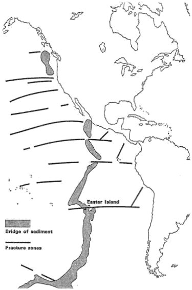 | Fig. 9.1 Francis Mazière thought that the legendary lost continent of Hiva might have been a long continental ridge (the East Pacific Rise). As explained below, growing evidence is emerging that far larger areas of the Pacific Ocean were once land. |
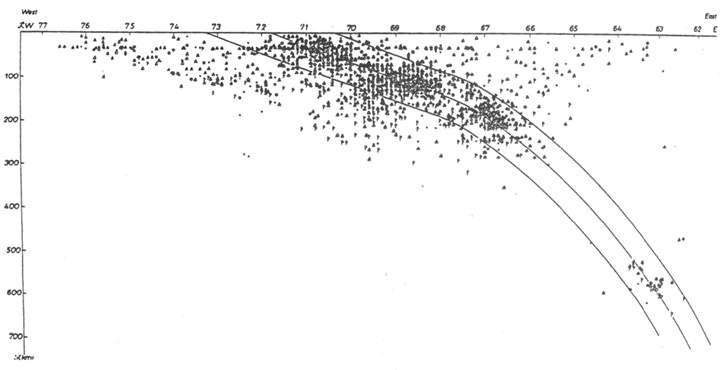
Plate tectonics – a dogma in distressAlthough most earth scientists jumped on the plate-tectonic bandwagon in the 1960s and 70s, the theory has always had its critics. Their number is increasing as evidence contradicting the reigning paradigm continues to accumulate.1According to plate tectonics, the earth’s outermost layer, or lithosphere, is divided into separate ‘plates’ that move with respect to one another on an underlying plastic layer known as the asthenosphere. The lithosphere is said to average 70 km in thickness beneath oceans, and to be 100 to 250 km thick beneath continents. However, seismic tomography (which produces 3D images of the earth’s interior) has shown that the oldest parts of the continents have very deep roots extending to depths of 400 km or more, and that the asthenosphere is absent or very thin beneath them.Even under the oceans there is no continuous asthenosphere, only disconnected asthenospheric lenses. In addition, the boundaries of the main plates are sometimes ill defined or nonexistent. These crucial facts – which go largely unmentioned in modern geological textbooks – render the large-scale lateral movement of individual ‘plates’ impossible.Plate tectonics claims that new ocean crust is constantly being created by upwelling magma at ‘midocean’ ridges (including the East Pacific Rise) and subducted back into the mantle along ocean trenches, mostly located around the Pacific Rim. This would mean that the entire ocean crust should be no more than about 200 million years old. Yet, although ignored by the textbooks, literally thousands of rocks of Palaeozoic and Precambrian ages have been found in the world’s oceans.For instance, the rocks forming the St. Peter and Paul islands near the crest of the Mid-Atlantic Ridge gave ages of 350, 450, 835 and 2000 million years, whereas according to plate tectonics they should be only 35 million years old. Rocks from central Tahiti in the South Pacific have proven to be over 800 million years old. Contrived and unconvincing attempts are occasionally made to explain such anomalies away – e.g. as crustal blocks that somehow got left behind during ‘seafloor spreading’.Everyone accepts that enormous areas of the present continents have repeatedly been submerged beneath the sea; about 90% of all the sedimentary rocks composing the continents were laid down under water.But due to their ingrained beliefs, plate tectonicists tend to ignore the growing evidence that there used to be large, now submerged, continental landmasses in the present oceans – landmasses that are completely ignored in imaginative reassemblies of today’s supposedly drifting continents. Several geoscientists have called for a major effort to drill the ocean floor to much greater depths to verify whether, as the data available already suggest, the basalt layer that is currently labeled ‘basement’ conceals more ancient sediments below it.2The earthquakes taking place at different depths on the landward side of ocean trenches define a Benioff zone, which is interpreted in plate tectonics as a ‘descending plate’. How ocean crust is supposed to descend into the denser mantle has never been satisfactorily explained.Moreover, Benioff zones have a highly variable and complex structure, with transverse as well as vertical discontinuities and segmentation, and bear little resemblance to the highly stylized pictures of continuous down-going slabs depicted in geological textbooks.

Fig. 9.2 Earthquake distribution perpendicular to the Andes (15-30°S).
The outlined ‘subducting slab’ appears to be a product of wishful thinking.3The volume of crust generated at ocean ridges is supposed to be equaled by the volume subducted. But whereas 80,000 km of midocean ridges are supposedly producing new crust, there are only 30,500 km of trenches and 9000 km of ‘collision zones’ – i.e. only half the length of the ‘spreading centers’. If subduction was really happening, vast amounts of oceanic sediments should have been scraped off the ocean floor and piled up against the landward margin of the trenches.However, sediments in the trenches are generally not present in the volumes required, and they do not display the expected degree of deformation. Plate tectonicists have had to resort to the far-fetched notion that soft ocean sediment can slide smoothly into a subduction zone without leaving any significant trace.An alternative view of Benioff zones is that they are very ancient fractures produced by the cooling and contraction of the earth, and currently represent the deformation interface between the uplifting island arc/continental region and the subsiding ocean crust and mantle.Most plate tectonicists believe that chains of oceanic islands and seamounts in the Pacific are the result of the Pacific plate moving over ‘hotspots’ of upwelling magma. This should give rise to a systematic age progression along hotspot trails, but a large majority show little or no age progression. For instance, the ages of islands and seamounts along the Sala y Gomez ridge (on which Easter Island and Sala y Gomez Island are located) fail to increase systematically to the east.4Hotspots are commonly attributed to ‘mantle plumes’ rising from the core-mantle boundary. But critics have shown that plume explanations are ad hoc, artificial, and inadequate, and that plumes are not required by any geological evidence.5 An alternative proposal is that ocean island chains are formed by magma that rises from much shallower depths, perhaps from a network of magma ‘surge channels’ in the lithosphere.The continents and oceans are covered with a network of major structures or lineaments, many dating from the Precambrian. In the Pacific basin there are intersecting megatrends, composed of ridges, fracture zones, and seamount chains, running NNW-SSE and WSW-ENE (fig. 9.3).6In plate tectonics, seamount chains supposedly indicate the direction of plate movement, but to produce these orthogonal megatrends the plates would have to move in two directions at once!Although plate tectonicists invoke ad-hoc ‘microplates’ and ‘hotspots’ whenever the need arises, they are unable to offer a satisfactory explanation of any of these megatrends, and prefer to ignore them. Fig. 9.3 The Pacific ‘plate’.Furthermore, some megatrends continue into the Australian, Asian, and North and South American continents where they link up with major Precambrian lineaments, implying that the ‘oceanic’ crust is at least partly composed of Precambrian rocks – as has been confirmed by deep-sea dredging, drilling, and seismic data. The Easter fracture zone lies on the Central Pacific Megatrend, which spans the entire Pacific and continues across South America into the Atlantic Ocean.7These interconnecting lineaments demolish the plate-tectonic myth that ‘plates’ and continents have moved thousands of kilometers over the earth’s surface.
Sunken continents
It is commonly argued that Easter Island can never have formed part of a continent because no granite or sedimentary rocks such as limestone and sandstone have ever been found there – only igneous rocks.But as H.F. Blandford pointed out back in 1890:[T]he occurrence of volcanic islands does not prove that the area in which they occur is not a sunken continent. If Africa south of the Atlas subsided two thousand fathoms [3660 m], what would remain above water? So far as our present knowledge goes, the remaining islands would consist of four volcanic peaks – the Cameroons, Mount Kenia, Kilimanjaro, and ... Ruwenzori, together with an island, or more than one, which, like the others, would be entirely composed of volcanic rocks.He added that there is ‘clear proof that some land-areas lying within continental limits have within a comparatively recent date been submerged over a thousand fathoms, whilst sea-bottoms now over a thousand fathoms deep must have been land in part of the Tertiary’.1Easter Island’s volcanic rocks consist mainly of basalts and andesites and a small amount of rhyolite. Basalts are considered to be a major component of the ocean crust, but flood basalts are also found in abundance on the continents. Furthermore, as more and more basalts are analyzed, the difference in the composition of oceanic and continental flood basalts is becoming increasingly blurred.2 In the plate-tectonic scheme, andesitic volcanoes are supposed to form along the edge of a continent, above a mythical subduction zone.3Easter Island of course now lies 3600 km from the nearest continent. The coarse-grained equivalent of rhyolite is granite, which is found in abundance on the continents – and increasingly under the oceans. Some geologists in the past have described Easter Island’s rocks bluntly as ‘continental’.4Plate-tectonicist P.E. Baker puts it more cautiously:‘the lavas in general are rather more siliceous than is usual for an oceanic setting’; rocks from other islands on or near the East Pacific Rise, such as Pitcairn and the Galapagos, are similar in this respect.5Soviet scientist N. Zhirov pointed out that ‘continental’ (sial) rocks such as granite, schist, rhyolite, and/or andesite have been found on many Pacific islands, including the Marquesas Islands, the Galapagos Islands, the Fiji Islands, the Tonga Islands, the Kermadec Islands, Chatham, Bounty and Oakland Islands, and Chuuk, Yap, and Man Islands in the Carolines. Most geologists nowadays prefer to assume that andesite and rhyolite rocks found in oceanic settings formed by high levels of fractional crystallization of oceanic basalts – but this is entirely hypothetical.6Continental crust is usually said to average 35 km in thickness compared to only 7 km for oceanic crust. The crust is 40 km thick beneath North Australia, 20 km thick in the eastern part of the adjacent Coral Sea, 22-28 km thick in the Fiji-Tonga-Samoa area, and as much as 36 km thick at the Tonga Islands.There are over 100 submarine plateaus and ridges scattered throughout the oceans, dotted with islands, and many may be submerged continental fragments that have not been completely ‘oceanized’, as suggested by ‘anomalously’ thick crust and finds of ‘impossibly’ ancient continental rocks.

Fig. 9.4 Worldwide distribution of oceanic plateaus (black).In the early 20th century, geologist J.W. Gregory concluded from a detailed survey of geological and palaeontological evidence that landmasses of varying sizes had been uplifted and submerged at various times in the Atlantic and Pacific oceans, most of them disappearing by the Miocene.He wrote:‘The direct geological evidence is overwhelming, that large blocks of the Earth’s crust rise and fall for vertical amounts greater than the greatest depths in the oceans.’7Russian geoscientist E.M. Ruditch concluded from a detailed study of ocean drilling results that there is no systematic correlation between the age of shallow-water sediments and their distance from the axes of the midoceanic ridges. This disproves the seafloor-spreading model, according to which the age of sediments should become progressively older with increasing distance from the midoceanic ridge.Some areas of the oceans appear to have undergone continuous subsidence, whereas others have experienced alternating episodes of subsidence and elevation. He believed that major areas of the oceans were formerly land. The Pacific Ocean appears to have formed mainly from the late Jurassic to the Miocene, the Atlantic Ocean from the Late Cretaceous to the end of the Eocene, and the Indian Ocean during the Paleocene and Eocene.8This corresponds closely to the theosophical teachings on the submergence of Lemuria in the Late Mesozoic and early Cenozoic, and the submergence of Atlantis in the first half of the Cenozoic.9Fig. 9.5The map of former land areas in the present Pacific and Indian Oceans presented in fig. 9.5 was compiled by geoscientists J.M. Dickins and D.R. Choi on the basis of ocean-floor sampling and drilling, seismic data, and the location of ancient sediment sources.10 Only landmasses for which substantial evidence already exists are shown, but their exact outlines and full extent are as yet unknown.Some geologists have argued that the area in the Southeast Pacific labeled S3 probably extended much further west and encompassed what is now Easter Island.11
Lost Pacific islands
Easter Island legends tell of the first settlers arriving after their native land had been submerged, and of a giant named Uoke, in a fit of anger, causing the subsidence of a large continent, of which Easter Island is a remnant. Similar traditions of vanished continents are found throughout Polynesia and Melanesia, and in other areas bordering the Pacific.For instance, the Hawaiians believed there was once a great continent stretching from Hawaii to New Zealand, but it sank, leaving only its mountaintops as islands. Such legends do not specify when the various landmasses are supposed to have existed. Although it is certain that no large continents in the Pacific have been submerged during the past few millennia, several writers believe that islands of reasonable size have done so.When the Dutchman Roggeveen discovered Easter Island in 1722, he was actually searching for Davis Land. An English buccaneer named John Davis reported sighting this island in 1687 in latitude 27°20'S. He said it was 800 km from the coast of Chile, low, flat, and sandy, but with ‘a long tract of pretty high land’ to the northwest. This description in no way applies to Easter Island. The general belief today is that Davis had misjudged his position, as was by no means unusual in the case of the early mariners, and that Davis Land was Mangareva, the chief island in the Gambier archipelago, far to the west of Easter Island.However, in the early 20th century Lewis Spence and John Macmillan Brown took the report of Davis Land at face value, and concluded that an archipelago of considerable extent must have foundered in this area between 1687 and 1722. Brown thought that Sala y Gomez, a rocky islet just above water some 415 km northeast of Easter Island, was probably the remains of Davis Land; there are numerous reefs around it and the water in its vicinity is shallow.1The Easter Islanders called it Motu Matiro Hiva, meaning ‘islet in front of Hiva’, Hiva being the name given to their legendary homeland.In addition to the Easter Island archipelago, Spence and Brown argued that land had also been submerged in several other parts of the Pacific within the last few thousand years.2They held, for instance, that the Caroline archipelago could be the remains of a vast island-empire in the eastern Central Pacific. The ruins of Nan Madol on Pohnpei, with its massive walls, earthworks, and great temples, intersected by miles of artificial waterways, would have required a workforce of tens of thousands (see section 10 below). Brown pointed out that within a radius of 2400 km there are no more than 50,000 people today, and added: ‘It is one of the miracles of the Pacific unless we assume a subsidence of twenty times as much land as now exists.’3On the little coral island of Woleai, some 1600 km west of Pohnpei, he found a written script still in use, quite unlike any other in the world (see section 7).Quite a few islands that mariners have reported on their travels have later gone missing.4
References
10. Megalithic Pacific

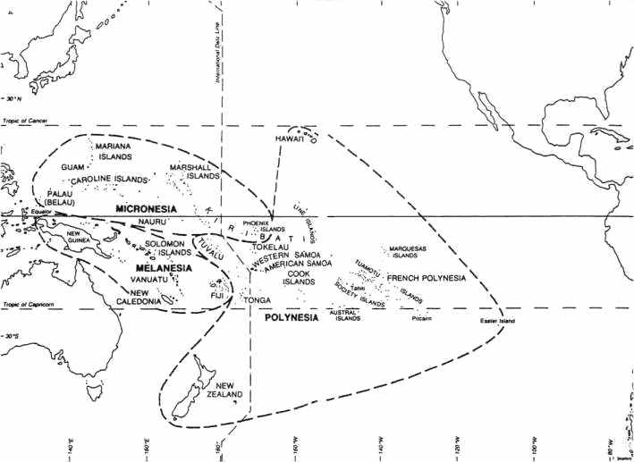
Fig. 10.1 The Pacific Ocean and its islands.The settlement of the Pacific is currently thought to have begun some 50,000 years ago, when hunter-gatherers first colonized Australia and New Guinea in the western Pacific, at a time when they were joined by land due to the lower sea level resulting from the ice age. Migration proceeded eastwards, and reached the northern Solomon Islands about 28,000 years ago.The Polynesian islands are believed to have been settled for the first time only within the last 2000 years or so, because the Polynesians took a long time to develop the navigational expertise enabling them to sail far offshore. However, dates for the settlement of the various Pacific islands are very tentative since they are based mainly on the oldest radiocarbon dates so far obtained; future discoveries may indicate that human habitation goes back countless millennia earlier.The history of even the past few thousand years is as yet poorly known. For instance, despite persistent denials by many orthodox archaeologists, there is growing evidence for transatlantic and transpacific contacts between a variety of ancient cultures, including the Egyptians, Libyans, Phoenicians, Greeks, Arabs, Hindus, Dravidians, Chinese, Mayans and Incas.1Some ancient maps provide tantalizing but controversial evidence that the earth had been mapped over 10,000 years ago, during the last ice age.2 There may have been several waves of migration into the Pacific from different directions, and over a time-span far vaster than mainstream archaeologists are willing to contemplate.The origin of the Polynesians has also been the subject of controversy. The prevailing theory in the late 1800s and early 1900s was that the Polynesians were an Indo-European group who came to the Pacific via India. Nowadays they are generally believed to have come partly from Northeast Asia and also from the Malay archipelago.But as Graeme Kearsley says:they are in many respects closely allied to Caucasians and were in many studies considered as such, and this racial heritage is still obvious in many islands in Eastern Polynesia as it was to the first European explorers. These migrations followed the same pattern as land migrations in that the male migrants, or mariners, traded, bought or captured marriage partners from coastal or island peoples thereby producing mixed race descendants. Therefore variable racial inheritance is clearly in evidence throughout the islands of the Pacific ...In almost all of the reports by the first Europeans there are references to the variable skin coloring of Polynesians on different islands, but also within the people of one island.Some Polynesians appeared to be Indians of the Americas, while others were of ‘Jewish’ type or wore turbans.Kearsley argues that there were trade links and cultural transfers from Asia, India, and the Middle East across the Pacific to South America, and at least a few contacts from South America across the Pacific back to Asia, with the result that the Andean and Peruvian cultures greatly influenced the Polynesians.3 ** H.P. Blavatsky has the following to say about the Polynesians: ‘there is in the Malay race (a sub-race of the Fourth Root Race) a singular diversity of stature; the members of the Polynesian family (Tahitians, Samoans, and Tonga islanders) are of a higher stature than the rest of mankind; but the Indian tribes and the inhabitants of the Indo-Chinese countries are decidedly below the general average. This is easily explained. The Polynesians belong to the very earliest of the surviving sub-races, the others to the very last and transitory stock.’4The following brief tour of the Pacific focuses on remains of monumental and megalithic architecture. As on Easter Island, some of the structures may be the work of very ancient and as-yet-unknown cultures.
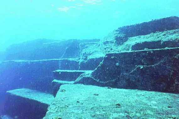
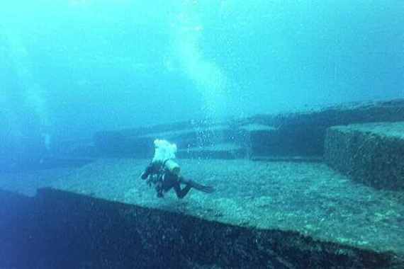
MicronesiaIn the mid-1980s a rectangular stone structure, measuring about 250 m long, 100 m wide, and 25 m high, was discovered off the small Japanese island of Yonaguni. It now lies in depths of up to 30 m of water but would have been exposed about 10,000 years, when the sea level was much lower, at which time it would have stood on the tropic of Cancer. The structure includes wide terraces, large steps, ramps and trenches, and two megalithic blocks 6 m high, about 2.5 m wide, and 4.9 m thick.Some of the stones show tool marks, and it seems likely that the structure is a natural geological formation that has been worked and modified by human hands.1


Fig. 10.2 Submerged structure near Yonaguni.2Other sunken structures have been found over a distance of 500 km between Yonaguni and Okinawa. They include paved streets and crossroads, huge altar-like formations, grand staircases leading to broad plazas, and processional ways surmounted by pairs of towering features resembling pylons.3Throughout the Mariana Islands latte stones are found – tall stone columns with a hemispherical capstone, looking like mushrooms. The upright stones usually occur in double rows of 6 to 14 stones. Latte stones range from small crude structures constructed of natural boulders to massive stone columns, square in shape, 4.5 m or more in height, capped with enormous blocks of stone.The island of Tinian has two of the largest standing megaliths. The pillars are 5.5 m in circumference at the base and 4.5 m at the top. They are 3.7 m high and support capitals 1.5 m high and 1.8 m in diameter. Each coral monolith weighs about 30 tons.There were originally 10 pillars arranged in two parallel rows, known as the House of Taga.4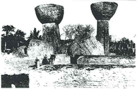 Fig. 10.3 House of Taga, Tinian.When the Spaniards first arrived in the early 16th century, the lattes were already partly in ruins. The natives (descendants of the ancient Chamorros) disclaimed all knowledge of the builders, and ascribed the stones to the ‘spirits of the before-time people’. Since the natives called them the ‘houses of the old people’ and still build their houses on supports, it is commonly assumed that the lattes once supported wooden houses, though no one has ever seen them used for that purpose.Another view is that the taller lattes once supported the roof of ancient temples, as in the Temple of Luxor at Karnak, Egypt.The marked differences in the shape, size, and quality of the lattes suggest that they could have been made by different cultures at widely different times. The earliest radiocarbon date from organic material found in the vicinity of the lattes is 900 AD – but this tells us nothing about when they were made. In 1949 two pieces of iron were discovered under the base of one latte pillar.These pieces of iron were not intrusive, and some archaeologists have concluded that at least one latte stone must have been erected after the arrival of the Spaniards – the possibility that earlier cultures on the island may have used iron is ruled out on ideological grounds.5Pohnpei (or Ponape, also called Ascension) is a volcanic island in the eastern Caroline Islands, and may have been the centre of a vanished empire. In the lagoon on the southeastern coast of Pohnpei lies Nan Madol, the ‘Venice of the Pacific’. It covers more than 18 square kilometers, but the core of the site is about 1.5 km by 0.5 km and contains 92 artificial islands built in the lagoon and surrounded by man-made canals. The islands were made by stacking large undressed hexagonal basalt prisms, most weighing under 10 tons, on the coral reef and filling in the centre of the islet with coral.The buildings are rather crude, but the scale of the work is very impressive. The largest structure, Nan Douwas, oriented to the cardinal directions, consists of two concentric perimeter walls separated by a seawater moat and enclosing a central pyramidal mound. The walls are made from basalt megaliths over 6 m long and reach 7.6 m in height, but could have been far higher originally.The largest stone, a massive basalt cornerstone on the southeast side of Nan Douwas, weighs around 50 tons.Fig. 10.4 Nan Douwas.6Between 500 and 750 thousand tonnes of building material were transported from varying distances to the site. Although legend speaks of the prisms being magically floated through the air, the official view is that they were carried on coconut palm rafts. Lost prisms can in fact be seen on the bottom of the lagoons along the route from the quarries, indicating that at least some were transported by this means.Ashes at the bottom of a fire pit on one of the artificial islands were dated to 1000 AD, but this only shows that the city was inhabited at that time – not that the entire city was built then. In any event, traces of an earlier layer of construction have also been detected.According to legend, two wise and holy men, Olosopa and Olosipa, selected the site of Nan Madol after they climbed a high peak and saw an underwater city below; Nan Madol was built as a ‘mirror image’ of its sunken counterpart. Legend speaks of two sunken cities and of underwater tunnels. The existence of extensive undersea ruins has been confirmed. They include a series of tall pillars standing on flat pedestals, reaching heights of up to 8 m.7The ancient giant stone city of Insaru on Lelu Island, which lies adjacent to Kosrae (the easternmost of the Carolines), was also made of huge basalt walls and pyramids, with the islands and buildings being intersected by a canal network connected with the ocean. The ruins are very similar to those of Nan Madol but not as extensive. Some of the walls are over 6 m high, and the megalithic basalt blocks weigh up to 50 tons. Whereas Nan Madol has sunk somewhat, Lelu appears to have risen slightly since the canals are almost dry.Where the stones came from is a mystery; legend says the city was built in one night by two magicians.
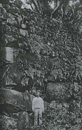 Fig. 10.5 Rare 1899 photo of one of the massive walls on Lelu Island.8On the Palau islands, the westernmost of the Carolines, over 5% of the land surface is terraced, and whole hills have been sculpted to resemble step pyramids. Some of the terraces are 4.5 m or more high and often 9 to 18 m wide. The terraces do not feature at all in local oral traditions, and no one knows who built them. The Bairulchan megalithic site on Babeldaob has two rows of large basalt monoliths, some with facial features carved on them.There are 37 stones in all, some weighing up to 5 tons, and the largest being 3 m tall. Similar monoliths can be found on Vao and Malekula in the Vanuata Islands (New Hebrides).
 Fig. 10.6 Part of a broken monolith on Malekula.9
Melanesia
On the Isle of Pines in New Caledonia there are about 400 large tumuli or mounds, ranging from 9 to 50 m in diameter, and 0.6 to 4.6 m in height. The material composing them seems to come from the immediate surroundings: coral debris, earth, and grains of iron oxide.The larger tumuli enclose cement columns of lime and shell matter, suggesting that the tumuli are the product of human activity. Many archaeologists doubt this as the early settlers did not use cement, and they theorize that the mounds were built by huge, now-extinct, flightless birds for incubating their eggs!However the cylinders inside the tumuli are of a very hard, homogeneous lime-mortar, containing bits of shells which have yielded radiocarbon dates of 5120 to 10,950 BC; even the later date is some 3000 years earlier than humans are believed to have reached the southwest Pacific from the Indonesian area.1
Polynesia
The Polynesian triangle stretches from New Zealand in the southwest to Hawaii in the north to Easter Island in the southeast. Nowhere in the Pacific are there as many impressive megalithic remains concentrated in so small an area as on Easter Island. Nevertheless, there are several notable structures on other islands.The island of Tongatapu in the Tonga Islands has the only megalithic arch in the South Pacific – the trilithon of Ha’amonga. Each of the upright coral pillars is 4.9 m high and weighs about 50 tons. The lintel, which is set into grooves in the upright stones, is 5.8 m long and weighs about 9 tons.One theory is that the trilithon was erected in the 14th century for a king to sit on as he drank an alcoholic beverage known as kava! Fig. 10.7 The trilithon of Ha’amonga.1The ceremonial centre of Mu’a (formerly Lapaha), a canal city on Tongatapu, has many megalithic platforms (known as langi). The central area of Mu’a was surrounded by a huge canal or moat. Massive rocks at an ancient port on the lagoon side of Mu’a indicate that huge vessels once docked there.The island has risen about a meter over the last few thousand years and such structures as the wharf and canal/moat are now useless. Langi Tauhala, a pyramidal platform at the old fortress of Tongatapu, is made of massive cut stone blocks.It contains probably the largest structural stone ever used by the Polynesians: measuring 7.4 m long, 2.2 m high, 0.4 m thick, and weighing 30 to 40 tonnes, it is notched and fitted into an adjacent block, and forms part of a wall 222 m long.
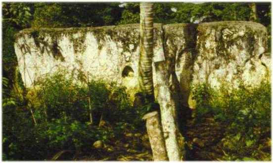 Fig. 10.8 The largest stone block in Langi Tauhala, Mu’a.The unusual notching can be seen on the far right.2
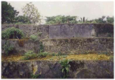 Fig. 10.9 Other stonework at Lapaha.On the basis of carbon-dating, Samoa is believed to have been settled by the Lapita people around 1200 BC, at about the same time as Tonga. On Savai’i island is an enormous flat-topped mound of stone blocks, known as the Pulemelei – the largest surviving mound in Polynesia. It covers 61 by 50 m at the base, and rises in two tiers to a height of over 12 m.At either end is a slightly sunken ramp to the top, together with a pavement, and it is surrounded by numerous other platforms, roads, and stone walls, as would befit a major ceremonial centre. On Upolu is another ceremonial centre consisting of immense earthen mounds, seven of which are truncated, rectangular pyramids. The largest of them surpasses the Pulemelei in size: it is 105.5 by 95.8 m at its base, about 12.2 m high, and appears to be made entirely of earth.The mounds are generally thought to have been used for the former royal amusement of pigeon-snaring, but it seems unlikely that this was their original purpose.
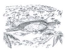
 Fig. 10.10 The Pulemelei mound (left) and a star-shaped mound (right) on Savai’i, Samoa.3Malden Island (one of the Line Islands, Republic of Kiribati [pronounced: Kiribas]), now uninhabited, has some 40 stepped pyramidal platform-temples, 3 to 9 m high, 6 to 18 m wide, and 27 to 60 m long, with traces of paved roads leading down to the sea.4On Rarotonga, the largest of the Cook Islands, piercing the ears and extending the earlobes were old customs, as was the case on Easter Island, in ancient India, and in Peru. The Rarotonga dialect is close to the Rapanui language. The island has a megalithic road that once encircled the entire island, as well as several pyramidal platforms.Some sections of the road were paved with perfectly fitting slabs, but most of it has now been paved over with asphalt. The kerbing is composed of neatly fitted blocks of prismatic basalt laid closely together. It is better constructed than the roads on Malden Island, and similar to those found in Peru.Rectangular enclosures associated with ceremonial platforms are set off from road.
 Fig. 10.11 Paved road encircling Rarotonga.5Truncated, pyramidal platforms, or marae, are found throughout the Society Islands, some consisting of megalithic stones, carefully shaped and fitted. The largest of all the Polynesian stone structures was Marae Mahaiatea on Tahiti. In overall appearance it was a stepped pyramid with a broad flat top. It measured 21.6 by 81.4 m at the base, and rose in 11 steps to a height of over 13 m.The courses were made of coral blocks, faced with squared volcanic stones. It is said to have been completed shortly before Captain Cook’s visit in 1769, but was demolished after 1897.
 Fig. 10.12 Marae Mahaiatea.6
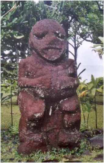 Fig. 10.13 The largest tiki found in Polynesia. It stands 2.75 m (9 ft) tall, and consists of 2 tons of basalt. It was carved on Raivavae (one of the Austral Islands), the religious centre of Polynesia, but now stands at Tahiti’s Gauguin Museum.Claims that the moai statues of Easter Island are a development of the Polynesian tiki are unconvincing.
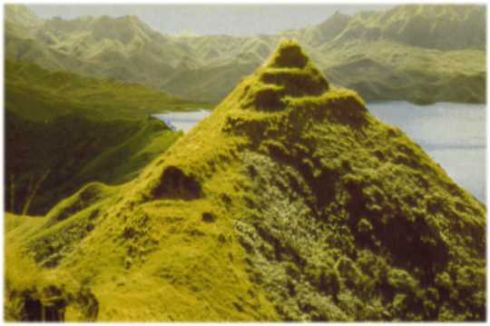
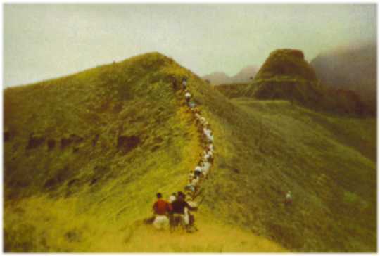 Fig. 10.14 On the remote island of Rapa – also known as Rapa Iti (Little Rapa) to distinguish it from Rapa Nui (Big Rapa, i.e. Easter Island) – the hills are carved with overgrown terraces and mysterious pyramids; it is not known who made them.7Marae Taputapuatea on Raiatea (the largest of the Leeward Islands) is 43 m long, 7.3 m wide, and up to 3.7 m high. It is thought to have been erected in the early part of the 2nd millennium AD, but was built over an older platform. It is one of the largest and best preserved platforms in Polynesia, and one of its most sacred sites.Like those of Raiatea, the marae on Huahine and Bora Bora are constructed of large coral slabs, whereas comparable structures on Tahiti and Moorea are made of round basalt stones.
 Fig. 10.15 Coral slabs in Marae Taputapuatea.
Fig. 10.16 Coral slabs in Marae Tainuu, Raiatea.Throughout the Marquesas Islands the remains of great stone platforms, walled house sites, and terraces, most of them overgrown with jungle vegetation, provide silent testimony of a vanished culture. The largest archaeological site in Polynesia is found on Hiva Oa, and occupies the whole of the Taaoa Valley. This partially restored site has over 1000 paepae (platforms on which houses were built), a large tohua (public ceremonial centre), and several me’ae (sacred platforms taboo to the public).Some of the platforms are 120 m long and 30 m wide, and contain cyclopean basalt blocks weighing over 10 tons. However, no carefully cut stonework comparable to Ahu Vinapu on Easter Island has been found.Fig. 10.17 Platform in the Taaoa Valley. Fig. 10.18 On the massive Te I’ipona me’ae at Puama’u on Hiva Oa stand
five huge stone tiki, the largest being 2.43 m tall.One of the most impressive archaeological sites is the unrestored ancient ceremonial centre in the Taipivai Valley on Nuku Hiva. It includes a massive platform, Vahangeku’a Tohua, built on an artificial terrace on a hillside.Measuring 170 by 25 m, it contains an estimated 6800 cubic meters of earth fill, and was faced by a wall almost 3 m high consisting of enormous basalt blocks, some of them 1.5 m high and just as broad.

Fig. 10.19 Megalithic 3-m-high wall of Vahangeku’a Tohua, Nuku Hiva.In 1956 archaeologist Robert Suggs carried out excavations at Hikouku’a in the Hatiheu Valley on Nuku Hiva, a sacred site that had long been concealed from western visitors. His crew dug several trenches in the huge platform in the hope of finding datable artifacts. Their finds included a musket used in the American Civil War, a French brandy bottle, and a glass bowl manufactured in Philadelphia in the late 1700s.Suggs concluded that the platforms had been constructed since the arrival of the Europeans in the Marquesas.However, novelist Herman Melville had visited Nuku Hiva in 1842, and described the massive platforms as being of such antiquity that his Marquesan guide said they were ‘coeval with the creation of the world’. Melville’s book on the subject appeared in 1846, 15 years before the American Civil War. Yet Suggs believed the platforms were still being constructed in the mid-1800s! He had fallen into the common error of assuming that the dates of artifacts or burials found in association with megalithic structures are reliable indicators of when the original structure was built.8The structures could of course be thousands of years older, and could have been renovated, rebuilt, or enlarged several times.Nowadays the Marquesas Islands have about 8000 inhabitants. The population is thought to have peaked at about 100,000 a few centuries ago, but was decimated following the arrival of the Europeans at the end of the 16th century.The Marquesas are frequently assumed to have been settled by people of western Polynesian origin, probably from Tonga or Samoa, around 300 AD, but Suggs argues that they were settled much earlier, around 300-500 BC. The islands are widely believed to have been one of the main points from which Polynesians spread throughout the Pacific; the Marquesan language is closely related to the languages of Hawaii, Mangareva, and Easter Island.A minority view is that the Marquesas were populated from Mexico or Peru, but opponents point out that no South American pottery or tools have ever been found in Polynesia. Nevertheless, there is evidence that the Marquesas, as one of the most easterly parts of Polynesia, played a key role in two-way contacts between Asia and the Americas. There are many cultural parallels between the Marquesas and the cultures of Mexico, Colombia, Ecuador, Peru, and Bolivia.For instance, ear elongation was practiced in the Marquesas, as it was in Peru. The Marquesans also practiced skull elongation, a custom found in Peru and also among the Flathead Indians of Montana. Bug-eyed statues similar to those found on the Marquesas are found in Bolivia and Peru, especially at Tiahuanaco and Chavin, and they have also been compared to Chinese Bronze Age statues. The ancient sacred centre of Nuku Hiva was probably the Taipivai Valley, which lies next to the sacred mountain of Taipi. Interestingly, the sacred centre at Tiahuanaco bears a similar name: Taypi.Near the temple platforms on Nuku Hiva, and on certain other Polynesian islands, sacred banyans were grown; banyans can also be seen growing from stone platforms in India.9
World grid
Many ancient cultures were familiar with the important astronomical cycle known as the precession of the equinoxes.1 Due to a very slow gyration of the earth’s axis, the spring equinox occurs about 20 minutes earlier every year, and the rising sun moves slowly against the backdrop of the zodiacal constellations from one equinox to the next, at an average rate of 1/72 degree per year. It therefore moves 1° in 72 years, 30° (one constellation of the zodiac) in 2160 years, and takes 25,920 years to make a complete circuit of the zodiac.2Numbers such as 54, 72, 108, 144, and 180 (all multiples of 18) are known as precessional numbers, and were assigned special significance in ancient societies.As Graham Hancock has pointed out, if we take the meridian of Giza-Heliopolis in Egypt as the zero-meridian for measuring longitude, we find that the great temple complex of Angkor Wat in Cambodia lies 72° east of the Giza meridian, the ruins of Nan Madol on Pohnpei lie 54° east of Angkor, and astronomically aligned megalithic structures on the islands of Kiribati and Tahiti, lie respectively 72° and 108° east of Angkor.The next significant precessional number is 144.When we look 144° of longitude east of Angkor (which is also 144° west of Giza), we find only one island in the vicinity: Easter Island, which lies just over 3° (barely 320 km) to the east of the exact location.Hancock suggests that Easter Island might originally have been settled,‘to serve as a sort of geodetic beacon, or marker – fulfilling some as yet unguessed at function in an ancient global system of sky-ground coordinates that linked many so-called “world navels” ’.The next significant precessional number is 180.Hancock writes:Exactly 180 degrees east of Angkor (and 108 degrees west of Giza), and almost exactly as far south of the equator (13 degrees 48 minutes) as Angkor is north of it (13 degrees 26 minutes), a colossal and unmistakable beacon does exist. It is the outline of a trident, or candelabra, 250 meters high, carved into the red cliffs of the Bay of Paracas on the coast of Peru and it is visible from far out to sea.It seems to point inland, towards the plains of Nazca to the south and the Andes mountains to the east.3 Fig. 10.20 Candelabra, Bay of Paracas.4
References


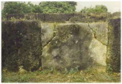
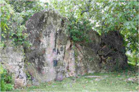

No comments:
Post a Comment